Thursday, March 6, 2014

MAGDALEN ISLANDS, CANADA


Reason to visit
An idyllic island getaway in the Gulf of St. Lawrence, Îles-de-la-Madeleine's (French) white sand beaches and sandstone cliffs are steadily eroding. Strong winds have always been part of life on the islands, and they make for notable kite surfing. But Canadian Geographic reported last year that the high concentration of sea ice currently shielding the archipelago's shores from destructive storms is disappearing. Climate researchers estimate the protective ice will be gone sometime between 2050 and 2090. Currently, anywhere from four to 43 inches of coast are lost each year, and intense storms can destroy up to three feet along certain cliffs.

Location 

The Magdalen Islands (French, Îles de la Madeleine) form a small archipelago in the Gulf of Saint Lawrence with a land area of 205.53 square kilometres (79.36 sq mi). Though closer to Prince Edward Island and Nova Scotia, the islands form part of the Canadian province of Quebec.

The islands form the territory equivalent to a regional county municipality (TE) and census division (CD) of Les Îles-de-la-Madeleine. Its geographical code is 01.
The islands also form the urban agglomeration of Les Îles-de-la-Madeleine, divided into two municipalities. These are Les Îles-de-la-Madeleine (2006 census pop. 12,560), the central municipality, and Grosse-Île (pop. 531). The mayors are Jonathan Lapierre and Rose Elmonde Clarke.


Ways to get there

Fly into Îles-de-la-Madeleine Airport, board a ferry from Prince Edward Island, or take a cruise from Montreal.


Things to do

  • Learning to kayak and canoe and sail at L’istorlet.
  • Bicycle the islands! They are only 100km by road.
  • Family camping and a multitude of family related activities at La Salicorne.
  • Learning to kite surf and sail surf at AeroSport Adventure Center.
  • Learn to ride horses at La Cringere au Vent Equestrian Center.
  • Take the family golfing on our nine-hole course or mini-golf at the 18-hole course at Sillons.
  • There are any number of eco-museums on the islands, Muse de la mer, CAMI, Salt Mine, Hydro-Quebec, Elie of Francois’s Museum,  Entry Island Museum, Aquarium, Seal Interpretation Center, and the Sand EcoMuseum are a few but every year brings new and exciting cultural activities.


Wednesday, March 5, 2014

REPUBLIC OF MALDIVES

Reason to visit
The highest point of Maldives is just 2.4 meters from the sea-level while the average is 1.5 meters. Reports says that 80% of the Maldives will be disappeared in the water grave if the sea-level rise just 1.5 meters. Currently there are 386,000 inhabitants in Maldives and all of them shall be relocated in India, Srilanka and Australia.
In 2009, the Maldives cabinet held a meeting underwater with the president Mohamed Nasheed to highlight the threat of global warming and rise in sea-level to Maldives. While underwater, they communicated through white boards and hand signals. 
Location

The Maldives archipelago is located on top of the Chagos-Maldives-Laccadive Ridge, a vast submarine mountain range in the Indian Ocean. Maldives also form a terrestrial ecoregion together with the Chagos and the Lakshadweep.The Maldives atolls encompass a territory spread over roughly 90,000 square kilometres (35,000 sq mi), making the country one of the world's most geographically dispersed. Its population of 328,536 (2012) inhabits 192 of its 1,192 islands. In 2006, Maldives' capital and largest city Malé, located at the southern edge of North Malé Atoll, had a population of 103,693. Malé is one of the Maldives' administrative divisions and, traditionally, it was the "King's Island" where the ancient Maldives royal dynasties were enthroned.
The Maldives is the smallest Asian country in both population and land area. With an average ground level elevation of 1.5 metres (4 ft 11 in) above sea level, it is the planet's lowest country. It is also the country with the lowest natural highest point in the world, at 2.4 metres (7 ft 10 in).Forecasts of Maldives' inundation is a great concern for the Maldivian people.

Ways to get there


By air: The international airport is located on the island of Hulhule. There are more than 2 dozens of international schedule flights flying into Maldives from major cities in asia, middle east and Europe. These include SriLankan Airways, Qatar airways, Singapore Airlines, Emirates, Indian Airlines, Balkan, Bulgarian Airlines, LTU, Condor, AOM French, Austrian Airlines and Malaysian Airlines, with some of these airlines flying daily, weekly or twice a week.
Another 14 companies offers regular charters, among them include Britannia Airways, Balair, Monarch Airlines, Lauda Air, Air Europe of Italy, Sterling Airways, Air Holland, South African Airways, Air Tours International connecting the Maldives to many centers of the world.

Things to do


Ten things you must do in the Maldives:
1. Swim with whale sharks or manta rays. The Maldives is one of the few places where you can snorkel alongside these gentle giants. 
2. Visit a traditional Maldivian village to meet the locals.
3. Explore the country’s capital, Malé.
4. Join local fishermen on a deep-sea fishing trip. 
5. Take to the sea on board a dhoni, a traditional wooden sailboat.
6. For the ultimate romantic treat, enjoy a sunset champagne cruise while spotting dolphins and flying fish.
7. Adopt your own coral reef at the Beach House Iruveli.
8. Be a castaway. Most resorts offer the option of time on a deserted island. 
9. Try an invigorating Maldivian massage at the Beach House Iruveli’s De’ Spa complex.
10. Get married. The Maldives is one of the world’s most popular spots to renew vows or have a wedding blessing.

REPUBLIC OF MADAGASCAR


Reason to visit
The main historical problem with international trade has been the correlated destruction of the environment. This is especially true when it comes to the issue of deforestation. In Madagascar, people have been cutting down the forests for decades. Throughout the past century, much of the rainforests of Madagascar have disappeared. People have begun moving out of the cities, industries have started to expand, and the use of land for farming (particularly coffee) has dramatically increased. All of these phenomenon have led to the destruction of the forest of Madagascar. This has become a major issue, not only because of the value that the forest have on the living environment on earth, but also because of Madagascar's unusual and rare species. Biologically, Madagascar is one of the richest areas on earth. Approximately five percent of the world's species reside in Madagascar, and the island has 8,0000 endemic species of flowering plants alone (New Scientist, 1990). However, this rare jewel of earth is in grave danger. Rapid deforestation, caused predominantly by the large population boom of the developing country, economic downturn, and mass migration to cities, is destroying much of the natural habitat of Madagascar.

Location

Madagascar is an island located in the western Indian Ocean. Madagascar lies about 425 km (266 miles) off the east coast of Southern Africa. Specifically, Madagascar is located east of Mozambique, across the Mozambique Channel. The geographic coordinates of Madagascar are 20 00 S, 47 00 E. 

Madagascar's land area is about 581,540 sq km (224,533 square miles) or slightly less than twice the size of Arizona. Madagascar has 4,828 km of coastline. 
Madagascar is the world's fourth largest island. Its most prominent feature would have to be the steep mountain range paralleling the entire eastern coast.

Ways to get there


Air: Cortez Travel can handle all of your travel arrangements - flights to Madagascar are available and prices are comparable for any of the following routings, and specials are offered year-round:
  • Via Paris: most direct routing from all U.S. and Canadian departure cities; no charge for stopover in Paris in either direction.
     
  • Via Johannesburg: may require an overnight in Johannesburg and generally recommended only when making arrangements for additional travel within South Africa.
     
  • Via Bangkok or Singapore: recommended only for those traveling from the West Coast (and going through Singapore would require at least two changes of plane en route).
     
  • Additional routings to include Mauritius or Reunion are possible and will be quoted upon request.
As a courtesy for trip planning purposes, we provide airline flight schedules for international flights to and from Madagascar, and for regional flight sand domestic flights in and around Madagascar.

Things to do

The things to do in Madagascar can be found nowhere else in the world.  There are animals and plants that are endemic that can’t be found anywhere else in the world including the Lemur Monkeys and even see through chameleons to name a few.  There are still parts of Madagascar that haven’t been discovered yet which is very rare for any country in the world.  It is one of the poorest countries in the world but also one of the safest countries in Africa thanks to the unique Malagasy culture.
Explore the Beaches
In Madagascar, you will find beaches that are on the tourist trails and others that haven’t even been explored yet.  There is something for everyone whether you are looking for luxury or something more authentic.  The most popular beaches are in Diego,  Anakao, the areas surrounding Morondava, and the islands of Nosy Be, Sainte Marie, & Nosy Ve.
Avenue of the Baobabs, Avenue of the Baobabs Sunset, Avenue of the Baobabs Madagasacar
Avenue of the Baobabs in Madagascar
Avenue of the Baobabs
The unique Baobab trees can be found all around the country.  Just an hour away from Morondava there are a unique set trees lined along the road where you can get exceptional pictures at sunset.
The Big Tsingy Stone Forest in Madagascar
The main tourist attraction in Madagascar that I came to see is beyond impressive.  It’s not easy getting there as it takes 1 complete day via 4×4 on very rough terrain.  There are two parks, Big Tsingy (large park) and the Small Tsingy (small park).  You won’t regret it!
Explore the Wildlife
There aren’t many other places in the planet that can say they have countless flora & fauna not found anywhere in the world.  Throughout the entire island you can find the 70 different species of Lemurs and see through chameleons as mentioned above.
Madagascar & the islands surrounding the country have eight plant families, five bird families, and five primate families that live nowhere else on Earth.  The parks you want to see are Berenty, Andasibe-Mantadia, Ankarana Montagne d’Ambre, Kirindy, Ranomafana, and Masoala.
Rice Terraces in Madagascar
Rice Terraces in Madagascar countryside
The Capital of Antananarivo (Tana)
While the capital of Madagascar doesn’t boast the architectural prowess of capitals in Europe, the city is unique in its own right.  The market that winds up and down the staircases will astound you.  Don’t forget to see the Royal Hill of Ambohimanga, Marché Artisanale de La Digue, and the Lemurs Park that is found just outside the city.
Diving in Madagascar
With so much coastline and unique plants and animals, its no wonder that Madagascar has great diving opportunities.  I was able to get my advanced diving certificate on the south western coast of the island.  The diving hotspots are mainly in the Northern coast in the cities of Nosy Be & Diego.  You can also find good diving in Ifaty, Anakao, Morondava, and around the islands of Sainte Marie.
A fisherman in Madagascar, fisherman
Interact With The Locals
I have to say that while most cultures from around the world are unique, the Malagasy people take it to a whole new level.  You can see the diversity on their faces and they are some of the nicest and welcoming people you will meet.  Always extremely curious and willing to talk to you (if you speak Malagasy or French).  Make sure to buy pens, candys, or even notebooks for the kids, they will love it.
Whale Watching in Madagascar
You are able to see humpback whales throughout the entire year near the waters of Saint Marie on the eastern coast.  The best time to see the whales is between June to September but you are still able to see them year round.


KOMODO ISLAND, INDONESIA


Reason to visit
The home of the world’s most famous reptile could end under the water surface in few decades if the Global Warming continues to progress. The sea surrounding the island is growing and could cause extinction of the Komodo dragon, but the increased acidification could also cause big damage, as it make the surface temperature higher, which may eventually kill the corals around the island and destroy the amazing diving sites.

Location

Komodo is one of the 17,508 islands that compose the Republic of Indonesia. The island is particularly notable as the habitat of the Komodo dragon, the largest lizard on Earth, which is named for the island. Komodo Island has a surface area of 390 square kilometres and a human population of over two thousand. The people of the island are descendants of former convicts who were exiled to the island and who have mixed with Bugis fromSulawesi. The people are primarily adherents of Islam but there are also Christian and Hindu congregations.
Komodo is part of the Lesser Sunda chain of islands and forms part of the Komodo National Park. In addition, the island is a popular destination fordiving. Administratively, it is part of the East Nusa Tenggara province.
Komodo lies between the substantially larger neighboring islands Sumbawa to the west and Flores to the east.

Ways to get there

Before setting out on your visit, and learning how to get to komodo,  it is important that you understand where you are heading and the easiest ways to get there. Komodo is in the middle of the Indonesian archipelago, and is between Sumbawa and Flores islands. The fact that Komodo is a UNESCO reserve for both a marine diversity and of course the Komodo Dragon makes this a growing tourist destination. The snorkeling and diving in the National Park is almost unsurpassed, and it is completely understandable as to why one would want to go. Now that you know where you are going let us discuss the best ways for you to get there. 
Any tour to Komodo will start and finish in Labuan Bajo. This is the main transportation hub for the whole province. There is the airport, ferries, buses, local boat service and multiple private car hire services.  With 5-7 flights a day to Denpasar and then onto international flights, it is readily accessible. There are daily ferries to Sape on Sumbawa and weekly ferry service to Sulawesi aboard Pelni. Due to time and accessibility, nearly all visitors fly in and out via Labuan Bajo Airport – it’s even called Komodo airport!
The personal way to visit Komodo is to charter a boat for at least 2 days with one 1 night on the boat. Certainly longer charters are available, and needed to see much more of the park. But to see the dragons, sleep in the park, visit a few beaches and snorkeling. Most of the charter boats are fairly small, with limited facilities, so any trip longer than 2 nights would require re-supply at LBJ. There are larger charter boats can go for about a week without re-supply, The small boats usually come with a crew of 2, captain and mate.
The boat choice is basically with or without a cabin. Boats with a cabin are usually a little bigger and include an upper deck sitting area. The upper deck sitting area is nice to have for photo taking or just escape from the boat’s noisy engine. Prices can vary wildly – but with good haggling you should pay about $300 USD for all food and beverage on the boat, including a full load of beer, sodas, and water. Komodo National Park Fees are not included and have to be paid directly to the park’s contract operator.
Things to do
  1. Loh Liang. The activities you can do: observing the Komodo, deers, hogs, birds; canoeing, etc.
  2. Pink Beach. The beautiful beach with the pink-coloured sand and alluring corals. The activities you can do: snorkeling and sunbathing.
  3. Loh Sebita. Loh Sebita is a mangrove area, thus observing the fauna and trekking are the interesting activities you can do here.
  4. Loh Buaya. The activities you can do: observing the Komodo, deer, buffaloes, birds, long-tailed monkeys and wild horses; canoeing.
  5. Kalong Island. The activities you can do: observing numerous bats in a colony. The best time to do this is at sunset when all the bats start to fly off to haunt food. It’s just amazing!
  6. Golo Kode. From the top of the hill known as Golo Kode, tourists may witness the enchanting panorama and fantastic landscape.
  7. Molo Strait.  The strait that has a swift current like the river flow at its hight tide.
  8. Cannibal Rock. Famous for its varied and colorful invertebrate life. Night dives are excellent, especially on the sandy slope of the northern side of the island starting at about 25 m depth.


Monday, March 3, 2014

GREAT BARRIER REEF, AUSTRALIA


Reason to visit
The Great Barrier Reef is one of the seven natural wonders of the world, home to an incredible diversity of sea life. It's the largest coral reef in the world, covering more than 345,000 square kilometers. But lately, the reef is losing more and more of its living outer layer. That's according torecent research in Proceedings of the National Academy of SciencesLooking back to 1985, scientists found that thenumber of living polyps has declined from more than 25 percent of the reef's surface to just under 14 percent. Most of that loss has come in the last decade or so in areas where humans live closest to the reef.
The problem is the number of challenges facing the reef. There's coral bleaching due to the hot temperatures induced by human-caused climate change. There's our sewage and agricultural runoff flowing into the sea. There are even outbreaks of coral-chomping starfish, aided and abetted by human activity. Not all is lost. The relatively pristine northern end of the reef shows that coral could recover, given the chance. For that to happen, we all will have to do more to combat climate change.

Location 
The Great Barrier Reef is the world's largest coral reef system composed of over 2,900 individual reefs and 900 islands stretching for over 2,600 kilometers (1,600 mi) over an area of approximately 344,400 square kilometers (133,000 sq mi). The reef is located in the Coral Sea, off the coast of QueenslandAustralia.
The Great Barrier Reef can be seen from outer space and is the world's biggest single structure made by living organisms. This reef structure is composed of and built by billions of tiny organisms, known as coral polyps. It supports a wide diversity of life and was selected as a World Heritage Site in 1981. CNN labeled it one of the seven natural wonders of the world.[8] The Queensland National Trust named it a state icon of Queensland.
A large part of the reef is protected by the Great Barrier Reef Marine Park, which helps to limit the impact of human use, such as fishing and tourism. Other environmental pressures on the reef and its ecosystem include runoff, climate change accompanied by mass coral bleaching, and cyclic population outbreaks of the crown-of-thorns starfish. According to a study published in October 2012 by the Proceedings of the National Academy of Sciences, the reef has lost more than half its coral cover since 1985.
The Great Barrier Reef has long been known to and used by the Aboriginal Australian and Torres Strait Islander peoples, and is an important part of local groups' cultures and spirituality. The reef is a very popular destination for tourists, especially in the Whitsunday Islands and Cairns regions. Tourism is an important economic activity for the region, generating over $3 billion per year.

Ways to get there
AIRPORT
There are no direct flights to the Great Barrier Reef, but Virgin Blue (www.virginblue.com.au) and Jetstar (www.jetstar.com.au) do fly from Brisbane, Cairns, Sydney & Melbourne to Hamilton Island and Proserpine (Whitsunday Coast). For flights from London, either go to Cairns or Brisbane, and from there you can travel by water taxi or seaplane to your island destination.

AIRLINES FROM THE UK
(0844 493 0787; www.britishairways.com) flies from London, via Brisbane, to Cairns; Qantas (020 8600 4300; www.quantas.co.uk) flies directly to Cairns; and Garuda Airlines (www.garuda-indonesia.com) offer seas return ticket to Cairns, via Bali.

Austravel (www.austravel.com) offers tailor-made package holidays to most islands, including Heron, Lizard, Dunk and the Whitsunday Islands. Tailor Made Travel (www.tailor-made.co.uk) has an 'Australia Naturally' brochure, which features personalised packages to the Great Barrier Reef and all around Australia.

In general, visiting the Great Barrier Reef is far from cheap, but most resorts do have cut-rate deals. Resort reservations made through local airlines or Qantas can produce savings, particularly in the cost of round-trip transfers, which are often not included in the resort rate and vary wildly. For last-minute travellers, standby packages are often available; travel agencies in Arlie Beach specialise in these: try Whitsunday Travel Centre (www.whitsundaytravel.com.au). When making reservations directly with a resort, ask about special deals and discounted rates.

Things to do
Great Barrier Reef Snorkeling Cruise
Great Barrier Reef Snorkelling Cruise
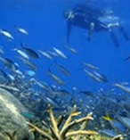
The beauty of the Great Barrier Reef is apparent as soon as you set your eyes upon it; however, put your head under the crystal-clear water and you'll be immediately exposed to the astounding array of beautiful life forms that dwell just under its surface.
A snorkeling trip will allow you to escape into this new world full of surprises, and a cruise that will take you to the magnificent Outer Reef to a spacious activity platform permanently moored at a wonderful site will serve as the ideal springboard for guests of all ages – swimmers and non-swimmers alike – to enjoy a day of discovery. You can snorkel directly from the platform and instantly find yourself among stunning coral gardens and colorful marine life – or you can take part in the Eco talks, reef presentations, board an air-conditioned semi-submersible for views without getting wet, and enjoy morning and afternoon teas along with a delicious gourmet lunch.
Outer Reef Snorkeling Cruise
Port Douglas Reef Snorkelling CruisePort Douglas provides another natural departure point to experience the joys of the Great Barrier Reef, and the Outer Reef in particular is in its own class; brimming with vibrant coral gardens and diverse marine life, it makes for one of the best snorkeling destinations in the entire world.
This cruise will take you aboard a speedy, wave-piercing catamaran all while in air conditioned comfort to the highly regarded Agincourt Reef – a jewel-like ribbon reef on the very outer edge of the Great Barrier Reef proper that showcases a series of unsurpassed coral formations, colorful marine creatures and an outstanding level of underwater visibility. A spacious activity platform awaits that allows you to participate in a huge range of reef activities including snorkeling and diving, semi-submersible viewing, fish feeding presentations and much more.

Green Island Day Trip

Green Island Day CruiseGreen Island is a stunningly beautiful coral cay that lies approximately 45 minutes off the coast of Cairns via catamaran that has existed for around 6000 years, and today acts as home to over 120 native species of plants and colorful bird life – a true nature lover's paradise in the heart of the Great Barrier Reef. A true paradise for nature-lovers, this day trip to Green Island includes snorkeling as well as an informative glass bottom boat tour that will allow you to fully explore this lovely island destination.
Many additional inclusions are provided within the package, such as the use of the island's great swimming pool and an Eco island walk to discover some of Green Island's distinctive rain forest flora. A range of restaurant and cafe-style lunch options along with additional activities including scuba and helmet diving, para sailing and scenic helicopter flights are also available upon request, making the day as involved or laid back as you choose.

Hot Air Ballooning

Hot Air Ballooning CairnsThe great heights that hot air ballooning will send you to will provide amazing views not only of the Great Barrier Reef itself but also the incredible natural surroundings that make up the geography of this tropical north Queensland region.
Ascend into the skies above Cairns and experience the sheer wonder, romance and silent serenity of the far north QLD bush land, golden sand beaches and stunning azure waters. After you've experienced the reef and the rain forest up close, a hot air balloon ride is the next best thing to do at the Great Barrier Reef – a breathtaking experience that cannot be missed!

Whitewater Rafting

Whitewater Rafting Cairns
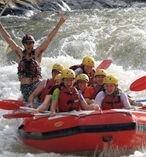
Pristine rain forest, crystal-clear rivers and breathtaking scenery are just a few of the reasons to take a whitewater rafting trip on the beautiful Russell and Barron Rivers, located just a short distance inland from the Great Barrier Reef. As some of the most popular rafting destinations in the world, these two great waterways offer unequaled chances for an affordable, exciting and exhilarating day out.
A series of different rapid courses ranging from grades one to four ensure that there is something available for people of all experience and skill levels, and most packages also include a relaxing picnic lunch. All rafting trips are guided by skilled guides who will show you the best ways to negotiate the rapids while maintaning a premium on safety so that you can simply enjoy the feeling of excitement without ever feeling a true sense of danger. Whether travelling as an individual, couple, or group, whitewater rafting near the Great Barrier Reef is an experience that will serve to make you feel more alive!

Low Isles Sailing Cruise

Low Isles Sailing CruiseSet sail for the Low Isles of the great barrier reef – a true tropical island paradise – that combines ideally with the inherent romance of sailing aboard a luxurious 30m sailing catamaran on this Low Isles Sailing Cruise. One of the true jewels of the Great Barrier Reef, the Low Isles are an idyllic series of unspoiled islands that provide a perfect microcosm of what the Reef and its surrounds are all about.
Mooring in a calm, picturesque lagoon, a huge range of reef activities await to be participated in including glass-bottom boat rides to view the wide array of marine life, snorkeling over the colorful coral gardens filled with turtles and brilliantly vibrant fish, guided beach walks, or simply relaxing on the beach or on the decks of the boat while soaking in some sunshine – taking time in the middle of the day to enjoy a delicious tropical buffet lunch.
Great Barrier Reef Scenic Helicopter Flight
Low Isles Sailing Cruise
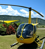
Flying from Port Douglas aboard a helicopter and heading out over the reef is one of the best ways to gaze down through the surface of its pristine, transparent waters to witness the coral and other marine life from directly above. Helicopter rides offer a vantage point of the Reef rarely seen by most people, as hovering at low altitudes allows you to witness the wonders that leave beneath from close up.
Once we reach your destination we'll land for a hot and cold tropical buffet lunch and give you the chance for a snorkeling adventure, underwater observatory, or semi-submersible viewing session to witness the reef from an under-the-surface perspective.

Explore the Daintree Rain forest

Daintree Rainforest Tours CairnsThe amazing blues of the ocean that blankets the Great Barrier Reef is not the only visually incredible display on offer in the region; look inland and you'll soon come across the vibrant greens of some of the oldest and most beautiful rain forest in the world – the ancient and World Heritage-listed Daintree Rain forest. Regardless of whether you choose to divide the day between the reef and the rain forest or spend your time exploring this wondrous green ecological playground, the Daintree will doubtlessly leave an impression on you that will last a long time.
Brimming with wonderful wildlife and lush surroundings that make this area of far north QLD one of the most popular holiday destinations in the world, you'll find some of the last vestiges of the most ancient rain forest where a combination of primitive animals, plants and an indigenous culture still thrive to this day.
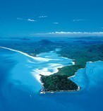
Take a Seaplane Flight over the Whitsundays
Whitsundays Scenic FlightsBordered by the Great Barrier Reef on one side and 74 tropical islands that lie in the calm waters of tropical north QLD's Coral Sea, the Whitsunday Islands lie midway along Queensland's coast. A huge number of spectacular destinations can be found within this island chain, including Heart Reef, Hardy Lagoon and White-haven Beach, and there are few better ways to gain an appreciation for their beauty than by a scenic seaplane flight that will take you directly above these natural marvels.
Travelling at varying altitudes and the ability to fly close to the ocean's surface means you'll be able to soak in the incredible colors and textures of the Whitsundays and the Barrier Reef in the span of half a day, with numerous different options available that each emphasize a different aspect of this stunningly beautiful Australian archipelago.
Whitehaven Beach CruiseRecently dubbed The Best Beach in Australia, White-haven Beach is an emblem that embodies what everyone's image of the Great Barrier Reef is all about. With its pristine white silica sand clashing beautifully with the surrounding vibrant blue waters, it's not hard to see why White-haven is such a highly regarded travel destination. Be sure to take some time to simply absorb the beach - it's the perfect excuse for some down time among the cavalcade of water sports and other activities you'll no doubt be otherwise occupying yourself with - by picking up a handful of the finely-grained sand and feeling it run through your fingers.
Various tours are available that will take you to White-haven Beach and offer different itineraries, and the majority offer a comprehensive look at all aspects of not just the beach but its surrounding islands and diving/snorkeling spots as well. Stretching out over a fairly substantial expanse of around seven kilometers in total, White-haven is not just some little pocket of beach that happens to be picture-perfect; it's a true, expansive beach that is large enough to ensure that even in peak seasons you'll likely still be able to garner a sense of solitude.
The beach is rarely overcrowded, and those visiting the Great Barrier Reef are advised to get their visit in quick as the beach's increasing worldwide fame and reputation may lead to its conditions beginning to deteriorate in the near future. You can book a full day cruise to White-haven by clicking the link below.

GLACIER NATIONAL PARK, UNITED STATE


Reason to visit
It's an oft-repeated statistic that the glaciers at Montana's Glacier National Park will disappear by the year 2030. But Daniel Fagre, a U.S. Geological Survey ecologist who works at Glacier, says the park's namesakes will be gone about ten years ahead of schedule, endangering the region's plants and animals.
The 2020 estimate is based on aerial surveys and photography Fagre and his team have been conducting at Glacier since the early 1980s. A more standardized measure of what's happening to a glacier comes from arduous documentation of its mass, which requires—among other techniques—multiple core samples.
Fagre is concerned about ecological implications of glacier melt. A lot of our sensitive and rare plants are associated with the edges of glaciers. At first, retreating glaciers will expose more growing area for plants. But eventually plants will crowd the area, and reduced water could cause drying and die-offs. And as glaciers retreat, the streams they feed can become intermittent.

Location

Glacier National Park is a national park located in the U.S. state of Montana, on the Canada–United States border with the Canadian provinces of Alberta and British Columbia. The park encompasses over 1,000,000 acres (4,000 km2) and includes parts of two mountain ranges (sub-ranges of the Rocky Mountains), over 130 named lakes, more than 1,000 different species of plants and hundreds of species of animals. 

This vast pristine ecosystem is the centerpiece of what has been referred to as the "Crown of the Continent Ecosystem", a region of protected land encompassing 16,000 square miles (41,000 km2).[3]
The region that became Glacier National Park was first inhabited by Native Americans and upon the arrival of European explorers, was dominated by the Blackfeet in the east and the Flathead in the western regions. Soon after the establishment of the park on May 11, 1910, a number of hotels and chalets were constructed by the Great Northern Railway. 

Ways to get there

By train

If you have the extra time and want to see more of the country, the train is a good alternative for traveling to Glacier National Park. Since much of the early development of the park was led by the Great Northern rail company, the railroad is an integrated part of the park's history (and vice versa). Amtrak's Empire Builder train service runs from Seattle and Portland through northern Montana, North Dakota, Minnesota, and Wisconsin to Chicago. The Empire Builder westbound arrives in the evening, the Eastbound train arrives in the morning, daily at the three stations serving the park. Travelers should arrange accomodations and/or waiting time accordingly.
By plane
Visitors to the park may fly to Glacier Park International Airport near Kalispell, Montana (IATA: FCA) (25 mi/40 km from West Glacier). It's possible to rent cars at the airport or take a shuttle (inquire first before making reservation to a particular airport if you do not wish to drive). Also, the destination of Missoula, Montana (IATA:MSO) is possible, though an additional 120 miles (190 km) must be driven. If you live near Los Angeles, San Francisco or Phoenix, there are non-stop flights to Missoula, so, unlike Kalispell, you won't have to connect.
By car
From the East: Take I-90 freeway to about 8 miles west of Missoula, then exit at US Hwy 93 north (Exit #96). In Kalispell, turn right at US Hwy 2 East (Idaho St.) From there it's 32 miles to the West Glacier entrance. OR, if you're approaching from North Dakota on US 2, it's a straight shot to Glacier Park. Heading west on I-94 across North Dakota, the shortest route to Glacier is exiting at Glendive to Montana highway 200s to Circle, then north on Montana 13 to east of Wolf Point, then west on Montana 25 to Wolf Point, then US 2 to Glacier Park. If coming from the South (Great Falls) or East (Havre) and your destination first is Waterton Lakes National Park, the fastest way is taking US 2 to Cut Bank, and then going north on Montana secondary 213 to Del Bonita, where it becomes Alberta highway 62. At the "town" of Del Bonita, Alberta (2 miles from the border) turn west on Alberta secondary 501 and go to Cardston, and then directly to Waterton Lakes on Alberta highway 5. This is signficantly faster than US 2/89 via Browning.
For East Glacier there are various routes including the I-15 Fwy (see From the South below). However, from the freeways, East Glacier via West Glacier is about the same time and distance. The best route for those wanting to avoid Montana's freeways and save over 250 miles is to follow I-94 just inside Montana from North Dakotaand exit #211. State Hwy 200S becomes 200 (no turns) and later becomes shared with US Hwy 87. On the west side of Great Falls where the highway merges into the freeway, take I-15 North for 12 miles and Exit #290 in Vaughn. On US Hwy 89 go 105 miles to Browning in the Blackfeet Indian Reservation. At the museum, turn left and take US Hwy 2 into East Glacier. (If using I-90 you can join this route via Billings. Follow State Hwy 3 at Exit #450, which is later shared with US 12 & 191. Turn left at the end of the highway at "Eddies Corner" and follow as above going to Great Falls.)
Don't underestimate the huge size of the state of Montana (550 mi/880 km wide). Glacier Park is actually closer to Seattle than it is to far eastern Montana.

From the West: Take I-90 freeway to Coeur d'Alene, Idaho (Exit #12, turn left) on to US Hwy 95. Where US Hwy 2 and 95 split north of Bonners Ferry, turn right to get US Hwy 2. From there, it's 167 miles to the West Glacier entrance. Don't forget to set clocks an hour ahead when entering Montana.
A slightly more ambitious (though fully paved) short cut is to stay on the I-90 freeway up to St. Regis, Montana (Exit #33). Then turn left on State Hwy 135 and go 21.6 miles, left on State Hwy 200 for 8.3 miles, right on State Hwy 28 for 46.7 miles, and left on US Hwy 93 in Elmo on Flathead Lake. In Kalispell, turn right at US Hwy 2 East (Idaho St.) This is a very scenic route along the Clark Fork River and Flathead Lake (which both contain all the waters of Glacier Park west of the Continental Divide) with farmlands in between. However, gas (petrol) and other services are limited between the freeway and Elmo.
Note: Using Hwy 200 east from Sandpoint, Idaho is not recommended, as all north-south connections with US Hwy 2 in between Libby and Kalispell are NOT paved! There's just no quick and easy way to get through the Cabinet Mountains beyond 15-20 miles from the Idaho border.

From the North (Canada): If first visiting Waterton Lakes National Park in Alberta, take Canada Hwy 2 south to the junction of the Crowsnest Hwy 3. Then go west (towards BC) 43 km and turn left at Pincher Station on Canada Hwy 6 for another 50 km. Turn right at the junction of Hwy 5 to enter the park. Upon leaving to get to Glacier, make two right turns just after exiting the park, and follow Canada Hwy 6 for 22 km to the U.S. border. This becomes State Hwy 17; turn right in 23 km onto US Hwy 89. The first park entrance is Many Glacier in 7 km (just after Babb).
Note: The international border is closed overnight between Waterton and Glacier, so via Cardston is only way in (see below). Bring US/Canadian pasport, passport card or enhanced driver’s license. If bypassing Waterton, take Canada Hwy 2 south to Cardston and cross the U.S. border. This becomes US Hwy 89. The first park entrance is Many Glacier 17 km from the border.
From the South: Take freeway I-15 North to Shelby, Montana (Exit #363) and turn left onto US Hwy 2. From there it's 70 miles to East Glacier. A short cut would be to exit I-15 in Vaughn, Montana (Exit #290) and take US Hwy 89 to Browning in the Blackfeet Indian Reservation. At the museum, turn left and take US Hwy 2 to East Glacier.
By foot
The Continental Divide Trail, a 3,100 mile United States National Scenic Trail, has its northern trailhead in Swiftcurrent Campground, accessible by car from Babbon Glacier Route Three. An alternate route starts from the Apikuni Trailhead, also located along Glacier Route Three. This trail exits the park at Marias Pass to the south and runs south along the Continental Divide to Mexico.

Things to do

  1. Biking - Bicycles are restricted to bike paths, roadways, and parking areas. Check the National Park Service's Glacier website for path, and road closures. Bikes are forbidden on trails. Bicycle rental is not available in Glacier National Park. It is possible to bike the length of Going-to-the-Sun Road, but the park limits bike access during peak traffic hours since many portions of the road do not have shoulders. The best times of day to go are the early morning or late afternoon. Although it is easiest to bike the road from east to west, be prepared for a steep elevation gain as you approach Logan Pass and cross the Continental Divide from either direction.
  2. Boating - Boat tours are available at Many Glacier, Two Medicine, Rising Sun, Waterton Lake, and Lake McDonald. Personal motorized boats are permitted on some of the park's lakes, but usually limited to 10 hp motors.
  3. Camping - There are several dozen backcountry campgrounds along the trail system, as well as frontcountry campgrounds available to motorists and RVers.
  4. Winter Activities - Park visitors during the winter (approximately December - April) may explore the park using skis or snowshoes. Some trails may be closed due to avalanche or snow-related hazards, and visitors should check conditions with a ranger before departure and check out after return.
  5. Fishing - Glacier is famous for its great trout fishing. Fishermen may fish without permits and can keep any fish they catch (except bull trout), but are advised to clean fish carefully: throw entrails into water far from shore, as the smell of fresh fish will attract bears.
  6. Hiking - Over half of the visitors to Glacier National Park report taking a hike along some of the park's 700 miles of trails. Hikers can purchase topographical maps, trail guides, and field guides at visitor centers. Guided day hiking and backpacking treks are available. Check the National Park Service's Glacier website for more info.The Trail of the Cedars, Huckleberry Mountain, Hidden Lake, Sun Point, and Swiftcurrent Nature Trails are hiker friendly and have signs that dot the trails to help hikers. The Trail of the Cedars is wheelchair accessible.
  7. Horseback riding - Most of the park's trail system is open to horses. Guided trips and horse rentals available at Many Glacier, Waterton Lake, Two Medicine, Rising Sun, and Lake McDonald Lodge.